As the U.S. attempts to pivot its national security focus to the Pacific, the situation in the South China Sea continues to grow more complex. China claims almost the entire area as its own and has running territorial disputes with nearly all of its neighbors, while tensions remain high in part due to the presence of a more aggressive People’s Liberation Army Navy.
The same day Pentagon leaders issued a new directive to focus the department on China, the PLAN has been deploying additional surveillance assets to one of its artificial island military bases in the South China Sea, according to new imagery reviewed by USNI News.
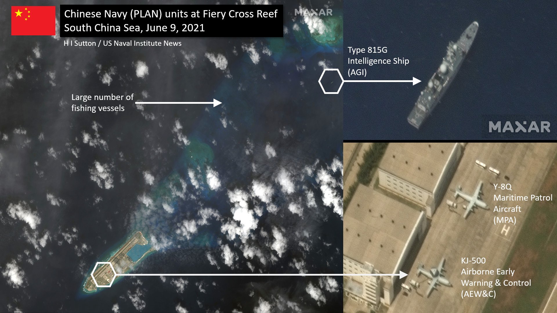
Satellite imagery from Wednesday provided by Maxar shows a Type-815G intelligence-gathering ship in the lagoon at Fiery Cross Reef in the Spratly Islands. On the airfield are a Chinese Navy Y-8Q maritime patrol aircraft and a KJ-500 airborne early warning & control (AEW&C) plane.
Fiery Cross Reef is one of several fortified artificial islands in the Spratlys. The Chinese government has used land reclamation to build a runway, harbor, and military base at its western end. The island is closer to Vietnam than mainland China and is also claimed by Vietnam and the Philippines.
These competing claims have caused simmering tensions, which occasionally rise into confrontations. In particular, the Chinese government has been conducting extensive surveys of the area, including in other country’s Exclusive Economic Zones (EEZs). A large part of this is because of natural resources. In addition to fish, the Chinese government appears keen to exploit untapped hydrocarbons lying beneath the seabed.
The U.S. Navy has found itself embroiled in these tensions. In May 2020, two U.S. Navy warships were deployed to conduct a presence operation near a Malaysia-contracted drillship. The ship, West Capella, had been harassed by Chinese government ships. This adds to numerous freedom of navigation passages and regional exercises.
China, too, appears to be scoping out the hydrocarbons hidden beneath the South China Sea. In 2019 a specialist ship, Hai Yang Di Zhi Ba Hao, surveyed the Vietnamese EEZ. This was despite protests from Vietnam. Analysis of the ship and her movements, shown in Automated Identification System (AIS) data shared by MarineTraffic.com, suggests that she was conducting a seismic survey. This involves using active sonar to penetrate beneath the seafloor and is mainly associated with undersea hydrocarbons.
Fiery Cross Reef also played a part in that episode. It is strategically placed deep in the South China Sea, a long way from China, yet relatively close to Vietnam. During the survey, Hai Yang Di Zhi Ba Hao made port calls several times at the reef.
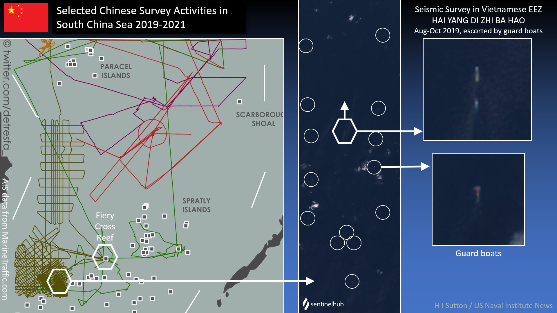
For the survey, Hai Yang Di Zhi Ba Hao was escorted by other vessels. It is not usual for seismic survey ships to work with smaller boats to clear the way and protect the vulnerable towed arrays from damage. But Hai Yang Di Zhi Ba Hao was at times escorted by 14 or more guard boats, according to satellite imagery. The photos indicate some of these were from China’s Maritime Militia.
The Maritime Militia forces are a constant aspect of the tensions. A significant number of fishing vessels, some part of the militia, are present at Fiery Cross Reef in the Maxar imagery.
China is accused, most recently by the Philippines, of using the Maritime Militia to push their territorial claims and exert pressure in a way that is difficult to counter by force, but denies doing so. Earlier this year, over 200 fishing vessels were massing at Whitsun Reef. The reef is administered by China, but also claimed by the Philippines and Vietnam, and lies within the Philippines’ EEZ, so the boats’ presence significantly raised tensions.
China has been conducting a range of other surveys in the area and further afield, in the Indian Ocean and, it is suspected in Indonesian sovereign waters. But the activities in the South China Sea are likely to continue to gather significant attention.


